Page content
Our research infrastructure supports the delivery of innovative, internationally competitive research that is central to our vitality.
Our facilities are continuously renewed by external grants and through targeted institutional funding to support our research strategy.
Below is a summary of our key research facilities.
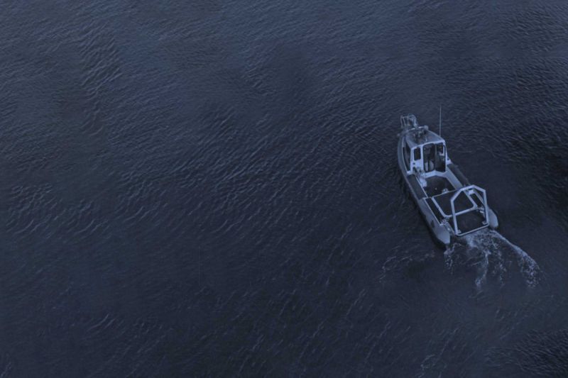
Bespoke state-of-the-art inshore vessel
In 2019, Ulster University prioritised £176k of DfE Higher Education Research Capital (HERC) funds and an additional £157k of institutional funding to purchase a bespoke state-of-the-art inshore vessel to strategically support CESDA’s ambitions to conduct multidisciplinary science at sea.
The new vessel has hydraulic gantry for launch and recovery of equipment, a RESON SeaBat 7125 multibeam echosounder and inspection class ROVs for high-resolution seabed mapping and hydrographic surveying in UK and Irish waters.
High Performance Computing (HPC) facility
We have developed a High Performance Computing (HPC) facility which supports significant model-based analyses of earth surface and oceanographic processes and patterns, including computational fluid dynamics (CFD), image based analysis and species distribution modelling.
Water chemistry facilities
Our water chemistry facilities include UV-VIS photometry, fluorescence spectrometry, DOC analysis and ion chromatography.
Microbiological analysis
We have provision for microbiological analysis, with climate cabinets and chambers available for temperature controlled experiments. Facilities for sediment analysis include equipment for freeze-drying, sieving, optical grainsize analysis, measurement of settling velocities and basic thermal analysis.
Our microscope suite has research grade dissection microscopes with computer aided image analysis and an inverted microscope for phytoplankton analysis. Scanning electron microscopy and fluorescence microscopy facilities are also available on campus.
High-resolution field equipment
We operate a suite of high-resolution field equipment for the investigation of urban, terrestrial, freshwater and marine environments. Survey platforms include GPS-enabled quad bikes, boats, quadcopter and fixed-wing drones mounted with various environmental sensors.
Laser scanners
We operate two laser scanners; one for high-definition imaging of terrestrial environments and the other for underwater investigations.
Coastal survey equipment suite
A £240,000 NERC-funded coastal survey equipment suite includes 18 load cell sediment traps, 16 audio impact sensors and 24 ultrasonic anemometers.
Monitoring and sensing suites
A dedicated £300,000 marine and freshwater acoustic remote sensing suite includes a multi-frequency ground penetrating radar, echosounders, chirp and boomer seismic profilers and sidescan sonar.
An instrumentation suite for high-resolution freshwater monitoring includes phosphorous and nitrate analyzers and multi-parameter water quality sondes.
Memberships
We are a member of the National Oceanography Centre Association, with representation on the NERC Marine Facilities Advisory Board.
We are also actively engaged with the National Marine Equipment Pool through the Marine Institute as an initiative to share access to specialist marine facilities and expertise across the island of Ireland.
Facilities Grants Awarded
Recent facilities grants awarded to staff demonstrate our applied research strengths.
These include grants awarded by NERC, the EU and the Marine Institute in this REF period:
Projects

Funding
Marine Institute Specialist Marine Research Equipment and Small Infrastructure award
Facility
Purchase of 2GRobotics ULS-500 Underwater Laser Scanner and Rotary Actuator
Investigators
- Dr Chris McGonigle - Senior Lecturer
- Mr David Rogers - Technician (Geophysical Sciences)
- Dr Rory Quinn - Reader
- Professor Derek Jackson - Professor of Coastal Geomorphology
Description
This project will examine the utility of underwater laser scanning to improve understanding of the structure and function of seafloor habitats and communities.
Underwater laser scanning, which has demonstrated capacity to resolve sub-centimetric features in areas with complex and rugged terrain, requires generating precise bathymetry over close physical ranges (2 m to 20 m).
Being able to record these data will facilitate fundamentally new kinds of observations, as well as allowing the flexibility to study fine scale ecological and geomorphological processes over shorter term time series.
This project has the capacity to make significant advances in the scientific community’s collective understanding of the physical, biological and chemical processes operating in the benthic environment.
Funding
Type 1: type 1: European Commission FP7 EUROFLEETS2 Regional 3 call
Type 2: NERC
Facility
- 6 days shiptime on Italian RV Minerva 1 and travelling expenses
- NERC Radiocarbon Facility
Investigators
Description
High-energy volcanic eruptions and ensuing mass transport of volcaniclastic debris pose a range of subaerial and submarine hazards, from the explosive events themselves to their capability of generating large tsunamis in the case of island or coastal volcanoes.
This project focuses on the Pantelleria volcanic complex in the central Mediterranean Sea with the aim of improving the understanding of the links between the subaerial and submarine volcanic processes.
Geophysical data and sediment cores collected during the Eurofleets2-funded research cruise will be used to:
- investigate the deep water record of high-energy eruptive events and the evolution of the volcaniclastic flows into the ocean
- link these events to the eruptive history of Pantelleria
- investigate the distribution of the associated mass flow deposits and relate them to respective eruptive events
- assess the mechanical properties of ash layers in relation to their possible behaviour as weak layers in downslope mass transport
- investigate the oceanographic history of the north-west basin and its role as oceanographic gateway between the eastern and western Mediterranean.
Funding
Ireland’s National Development Plan 2016 Ship-Time Programme
Facility
4 days of ship time on RV Celtic Explorer
Investigators
Dr Paul Dunlop, Dr Sara Benetti
Partners
Ulster University, Marine Institute, Memorial University Newfoundland, Geological Survey Newfoundland, Geological Survey of Canada Atlantic
Description
This project aims to fill in knowledge gaps in the current understanding of the full extent of the Newfoundland Ice Sheet and its retreat pattern.
This paleo-ice sheet provides a key location for examining ice sheet interactions with external drivers such as changes in oceanic circulation, sea level and climate from the wider North Atlantic region.
The research cruise targeted the southern continental shelf of Newfoundland and worked across several fjord-mouth systems collecting new multibeam bathymetry, seismic and core data over a series of submarine moraines.
The work on the datasets is going and is focusing on the investigation of the pattern and timing of retreat of the ice sheet from its marine extension.
A full reconstruction of the marine sectors of this former ice sheet will provide important new information on how contemporary marine influenced ice sheets might respond to future climate change.
Funding
NERC
Facility
Airborne Research Facility
Description
This project will examine the utility of underwater laser scanning to improve understanding of the structure and function of seafloor habitats and communities.
Underwater laser scanning, which has demonstrated capacity to resolve sub-centimetric features in areas with complex and rugged terrain, requires generating precise bathymetry over close physical ranges (2 m to 20 m).
Being able to record these data will facilitate fundamentally new kinds of observations, as well as allowing the flexibility to study fine scale ecological and geomorphological processes over shorter term time series.
This project has the capacity to make significant advances in the scientific community’s collective understanding of the physical, biological and chemical processes operating in the benthic environment.
Funding
Marine Institute: National Research Vessels Shiptime Programme
Facility
14 days shiptime on RV Celtic Voyager
Investigators
- Dr Ruth Plets - Lecturer in Marine Science (Marine Geology)
- Dr Rory Quinn - Reader
- Dr Kieran Westley - Research Associate
- Dr Chris McGonigle - Senior Lecturer
Description
The project looks at the current state of and the prevailing physical, chemical and biological processes occurring at WWI wrecks sites in the Irish Sea.
Fieldwork included high-resolution multibeam surveying and ground-truth sampling over 12 metal wreck sites.
The outcome of the project will:
- help heritage managers to construct effective site preservation and management strategies,
- develop best-practice surveying guidance for shipwreck imaging
- allow the wider public to engage with a heritage that is otherwise intangible and inaccessible through the development of high-definition digital models.
Funding
NERC
Facility
Geophysical Equipment Facility
Investigators
Description
Understanding long-term dynamics of high magnitude coastal storms is important in defining the impact and frequency of these events on soft sedimentary coasts.
Isolating the timing and extent of such events is difficult, however, prograded beach and dune environments can often preserve a distinct record of these events in their morphology via paleo-scarps and/or erosional unconformities.
Instrumented records of storm events are only relatively recent and therefore for decadal to centennial timescales we must adopt alternative methods of unravelling (large) coastal storm events.
Recent reconstructions of rapid coastal geomorphic changes and oceanographic events in the North Atlantic, have suggested a strong link between storminess and the North Atlantic Oscillation (NAO).
This project uses Ground Penetrating Radar to present a new storm chronology, based on subsurface erosional features, locked within large coastal dune systems of western Ireland over the late Holocene period.
Funding
NERC
Facility
NERC Cosmogenic Isotope Analysis Facility
Investigators
- Dr Paul Dunlop - Research Director - Geography & Environmental Sciences
- Dr Sara Benetti - Senior Lecturer
Description
This project is investigating the dynamic behaviour of the former British-Irish Ice Sheet in western Ireland with a focus on correlating the offshore glacial history with the adjacent terrestrial landscape in Co. Mayo.
The glacial and glaciomarine record is being investigated using a multiproxy approach that involves interpretation of geophysical data of the shelf adjacent to Co. Mayo, sedimentological analysis of sediment cores retrieved from moraines on the shelf and fourteenth century dating of marine microfauna of specific lithofacies to date the glacial retreat offshore. Conversely, cosmogenic exposure analysis from moraines and erratics onshore will constrain the onshore deglaciation.
This combined approach will build a more detailed picture of the timing and forcing of glacial dynamics in this region and will provide important information on the stability of marine based ice sheets and their deglacial behaviour during deglaciation.