Glaciers are a sensitive indicator of climate change – and one that can be easily observed. Regardless of altitude or latitude, glaciers have been melting at a high rate since the mid-20th century. Until now, however, the full extent of ice loss has only been partially measured and understood.
Now an international research team led by ETH Zurich and the University of Toulouse, including Dr Robert McNabb from Ulster University’s School of Geography and Environmental Sciences, has authored a comprehensive study on global glacier retreat, which is due to be published in Nature on 28 April. This is the first study to include all the world’s glaciers – around 220,000 in total – excluding the Greenland and Antarctic ice sheets. The study’s spatial and temporal resolution is unprecedented – and shows how rapidly glaciers have lost thickness and mass over the past two decades.
Rising sea levels and water scarcity
What was once permanent ice has declined in volume almost everywhere around the globe. Between 2000 and 2019, the world’s glaciers lost a total of 267 gigatonnes (billion tonnes) of ice per year on average – approximately 76 times the volume of Lough Neagh, or enough to cover the island of Ireland in three metres of water every year.
The loss of glacier mass also accelerated sharply during this period. Between 2000 and 2004, glaciers lost 227 gigatonnes of ice per year, but between 2015 and 2019, the lost mass amounted to 298 gigatonnes annually.
Glacier melt caused up to 21 percent of the observed rise in sea levels during this period – some 0.74 millimetres a year. Nearly half of the rise in sea levels is attributable to the thermal expansion of water as it heats up, with meltwaters from the Greenland and Antarctic ice sheets and changes in terrestrial water storage accounting for the remaining third.
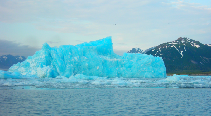
Among the fastest-melting glaciers are those in Alaska, Iceland and the Alps. Dr Robert McNabb, co-author of the study and Lecturer in Terrestrial Remote Sensing of Environmental Systems at Ulster University’s Coleraine campus explains:
“Glacier meltwater is an extremely important water source in many regions such as High Mountain Asia or the Andes in South America. While increased glacier melt can provide extra water in these regions right now, it’s really a diminishing return. If these trends continue in the future, it could lead to water and food shortages in regions that rely on meltwater runoff. Glacier melt is a key indicator of climate change, and our observations can be used to improve hydrological and glacier models, leading to more accurate predictions over the next few decades.”
Divergent glacier retreat patterns in some regions
To their surprise, the researchers also identified areas where melt rates slowed between 2000 and 2019, such as on Greenland’s east coast and in Iceland and Scandinavia. They attribute this divergent pattern to a weather anomaly in the North Atlantic that caused higher precipitation and lower temperatures between 2010 and 2019, thereby slowing ice loss.
The researchers also discovered that the phenomenon known as the Karakoram anomaly is disappearing. Prior to 2010, glaciers in the Karakoram mountain range were stable – and in some cases, even growing. However, the researchers’ analysis revealed that Karakoram glaciers are now losing mass as well.
Study based on stereo satellite images
As a basis for the study, the research team used imagery captured on board NASA’s Terra satellite, which has been orbiting the Earth once every 100 minutes since 1999 at an altitude of nearly 700 kilometres. Terra is home to ASTER, a multispectral imager with two cameras that record pairs of stereo images, allowing researchers to create high-resolution digital elevation models of all the world’s glaciers. The team used the full archive of ASTER images to reconstruct a time series of glacial elevation, which enabled them to calculate changes in the thickness and mass of the ice over time.
Together, the co-authors on the study spent over three years developing the techniques to process the satellite images, and 18 months analysing the data and results. To process the data, the researchers used a supercomputer at the University of Northern British Columbia. Their findings will be included in the next Assessment Report of the United Nations Intergovernmental Panel on Climate Change (IPCC), which is due to be published later this year.
Co-author Daniel Farinotti, Head of the glaciology group at ETH Zurich and the Swiss Federal Institute for Forest, Snow and Landscape Research WSL commented:
“Our findings are important on a political level. The world really needs to act now to prevent the worst-case climate change scenario.”
Alongside the University of Toulouse, ETH Zurich and Ulster University, other institutions that participated in the study include the University of Oslo in Norway and the University of Northern British Columbia in Canada.
Read the full study published in Nature.